Researchers Combine Atmospheric Science with Heartland Farming
Field studies use aircraft, satellite, and ground-based sensors to examine effects of land use on regional climate
June 7, 2007
The following news release is being issued today by the U.S. Department of Energy's Pacific Northwest National Laboratory. Mark Miller, an atmospheric scientist at DOE's Brookhaven National Laboratory, is leading the largest component of this research program, and several other Brookhaven scientists are also participating. These Brookhaven scientists will be available for interviews during a special Ponca City, Oklahoma, media day on June 11 (see: media advisory). For more information about Brookhaven's role in this work or to speak with the Brookhaven scientists at other times, please contact Karen McNulty Walsh, (631) 344-8350, kmcnulty@bnl.gov.
Media Contact: Lynne Roeder, 509-521-2922
This week, two major scientific field studies begin in Oklahoma to investigate major uncertainties in climate models-aerosols and clouds. Both campaigns are focused on fair weather clouds, but one is studying the influence of land surface changes, such as soil moisture, on cloud formation, while the other is investigating the effects of urban aerosols on clouds. Given the influence of large-scale agricultural operations across the Great Plains area, this field research will gather important information about these relationships for regional climate change studies.
The two studies will bring nine research aircraft and dozens of additional ground-based sensors to Oklahoma in June.
"A variety of processes - such as surface moisture and particulates in the air - drive regional climate systems, particularly through their influence on the lifecycle of clouds," said Pacific Northwest National Laboratory scientist Beat Schmid.
The $5.5 million multi-partner effort is coordinated by PNNL and sponsored by two Department of Energy programs. It will include nine scientific aircraft and dozens of ground-based instrument platforms. These capabilities will allow researchers to obtain a focused data set during a key season in the region - the winter wheat harvest, which coincides with fields of fair weather clouds throughout the Midwest.
Oklahoma is not only one of the largest agricultural producers in the country, but its highly variable weather provides an outdoor laboratory for climate studies. The DOE, the National Oceanic and Atmospheric Administration, and the Department of Agriculture all have extensive research facilities throughout the area. In addition, satellites from the National Aeronautics and Space Administration routinely pass over these facilities. From June 9-30, the two campaigns will supplement these existing research capabilities with additional airborne and ground-based instrumentation.
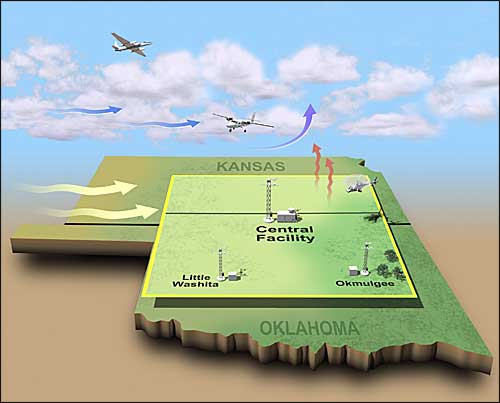
The larger campaign, called the Cloud and Land Surface Interaction Campaign, or CLASIC, is investigating how changes in land use affect clouds through changes to surface heating and associated dynamics. It is sponsored by the DOE Atmospheric Radiation Measurement Climate Research Facility (ACRF), and is focused over the ACRF Southern Great Plains (SGP) site in Oklahoma.
This site covers 55,000 square miles of land between central Oklahoma and southern Kansas. Its array of remote sensing instrumentation collects continual data about clouds, aerosols and radiation, which are made freely available to the global scientific community via the internet.
During CLASIC, operations at the SGP site will be enhanced with additional sensors and observation towers for measuring changes in carbon dioxide and moisture levels. Seven instrumented research aircraft, including a helicopter, will fly at various altitudes to obtain data from below, in and above the clouds.
"The dynamics that occur between the land surface and the atmosphere are important mechanisms in regional climate, but because of the broad and complex range of disciplines involved - surface vegetation, moisture, clouds, aerosols, and solar energy exchange - it's very difficult to connect all the dots," said Mark Miller from Brookhaven National Laboratory and lead scientist for CLASIC.
The second campaign, called the Cumulus Humilis Aerosol Processing Study, or CHAPS, is sponsored by DOE's Atmospheric Science Program. Scientists involved with this campaign are seeking to better understand how aerosols affect cloud properties, such as water concentration and droplet size distributions, and also how clouds affect the properties of aerosols, such as their chemical composition or location in the atmosphere.
Concentrated around Oklahoma City, CHAPS scientists will use two aircraft to measure aerosol composition and related chemistry, and launch weather balloons to record the state of the atmosphere. Information from this campaign will be compared with new algorithms that represent cloud and aerosol processes in climate models.
"By having these two campaigns co-located in Oklahoma, scientists from each campaign can use a suite of observations from the other to extrapolate their results to broader geographical areas," said Carl Berkowitz from PNNL and lead scientist for CHAPS.
The start of these campaigns represents the culmination of nearly two years of preparation and coordination among the participating organizations, including NOAA, NASA, USDA, and numerous national laboratories and universities.
Participating DOE national laboratories and user facilities include: PNNL, Brookhaven National Laboratory, Argonne National Laboratory, Lawrence Berkeley Laboratory, Los Alamos National Laboratory, Oak Ridge National Laboratory, the ARM Climate Research Facility, and the Environmental Molecular Sciences Laboratory.
For more information about CLASIC, see http://science.arm.gov/clasic.
For more information about CHAPS, see http://asp.labworks.org/.
# # #
2007-10644 | INT/EXT | Newsroom