City of Storms Gets an Intensive Look
A focused measurement effort on convective activity around Houston, Texas, begins in June
May 17, 2022
By Corydon Ireland, Staff Writer, Pacific Northwest National Laboratory
 enlarge
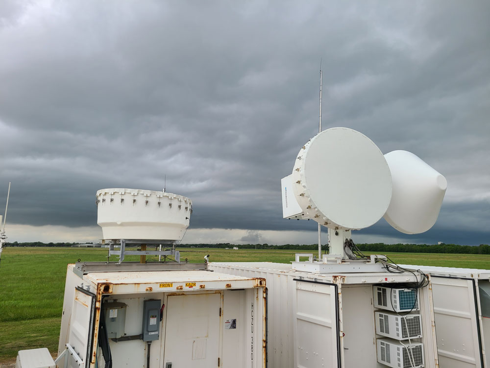
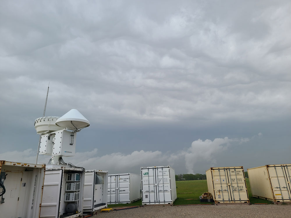
On April 25, 2022, afternoon convection looms on the horizon behind ARM radars collecting data in La Porte, Texas, during the TRacking Aerosol Convection interactions ExpeRiment (TRACER). Photo is by Mark Spychala, Hamelmann Communications.
The following story about a Texas-based study of atmospheric conditions and their connections with pollution and weather was published today by the U.S. Department of Energy’s (DOE) Atmospheric Radiation Measurement (ARM) user facility. Michael Jensen, a meteorologist at DOE’s Brookhaven National Laboratory, is the lead scientist for this field campaign, which is known as TRACER. For more information about Brookhaven’s role in TRACER, contact Karen McNulty Walsh, Brookhaven Lab Media & Communications Office, kmcnulty@bnl.gov, 631-344-8350.
Houston, Texas, is a subtropical metropolis of 2.3 million people. Thunderstorms in or near the city occur every month. But nature delivers convective storms most frequently during summers.
That’s when reservoirs of warm, moist air from the Gulf of Mexico clash with cooler, drier air from the north. The warm air then lifts—convects—upward to form clouds and thunderheads.
Within these ascending clouds, moisture condenses to form cloud droplets. Some grow large enough to fall as precipitation. Then downdrafts hit the surface in cool gusts of air, punctuated by lightning.
From June through September 2022, these conditions will draw atmospheric scientists in great numbers to stormy Houston. They are part of an intensive phase of study for an international, multi-agency field campaign called the TRacking Aerosol Convection interactions ExpeRiment (TRACER).
In the video above, Michael Jensen, TRACER's lead scientist, describes the campaign's science focus and why the Houston area is a prime location for TRACER.
The U.S. Department of Energy (DOE) is funding the core instruments and the lead scientists for the yearlong TRACER field campaign, which began in October 2021.
DOE calls TRACER’s summer phase an “intensive operational period,” or IOP, when a field campaign’s tempo increases.
IOPs are scheduled for when conditions for recording observations will be optimal.
“We fully expect there will be lots of convection for us to observe,” says TRACER lead scientist Michael Jensen, a meteorologist at DOE’s Brookhaven National Laboratory in New York.
ARM AND OTHER ACTORS
 enlarge
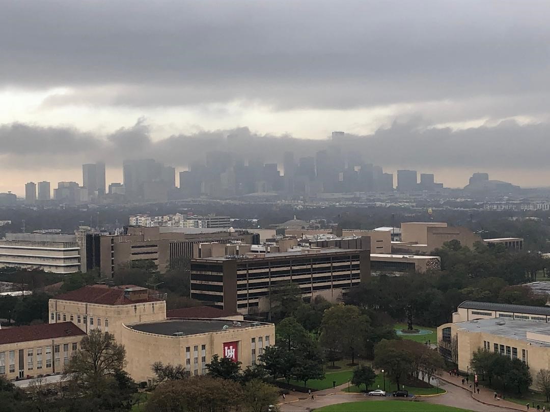
Taken from the Moody Tower observatory in Houston, this photo shows the University of Houston, foreground, and the downtown skyline arching into a cloud deck. Photo is courtesy of Jensen, Brookhaven National Laboratory.
During the TRACER IOP, DOE and its campaign partners will put additional instruments at ground sites. There will be instrumented boats, balloons, trucks, and research aircraft taking part too.
Key surface instruments for TRACER come from DOE’s Atmospheric Radiation Measurement (ARM) user facility. ARM operates fixed-location and mobile observatories in climate-critical regions of the world.
Campaign partner institutions number more than 30 universities; seven DOE national laboratories; one Texas state agency; and other federal agencies, including NASA, NOAA, and the National Science Foundation (NSF).
A timeline of related campaigns is available on ARM’s TRACER web page.
HOUSTON: AN IDEAL HOST
TRACER represents the first deployment of ARM instruments in an urban coastal environment. Its science motivations include yearlong intensive looks at how aerosols interact with storms.
Ultrafine liquid and solid atmospheric aerosol particles are needed to form cloud droplets. In Houston, aerosols come from a variety of sources, including factories, car exhaust, rural soils, and sea spray.
During the IOP, scientists will step up their observations of how thunderstorm strength is influenced not only by aerosols, but by sea breezes, and the urban heat island effect.
Cities generally have “heat islands”—dense concentrations of impervious surfaces from roads and buildings. These surfaces absorb and retain more heat than trees, grass, and other natural land cover.
In addition, pollution levels are higher than in rural areas. Pollution disturbs the atmosphere in ways that may intensify thunderstorms.
The campaign also gives researchers an outdoor laboratory for studying two big issues: how long aerosols persist in the atmosphere and the life cycles of convective clouds in an urban coastal environment.
Data from existing instrument networks around Houston will complement TRACER data. These networks measure local air quality and meteorology and map lightning.
Houston offers a lot of local human resources to TRACER as well. For one, Jensen pointed to the University of Houston’s James Flynn, an aerosol-transport expert.
Before TRACER began, Flynn called it “one of those projects that is very applicable to everyday life here in Houston.”
CITIES IN FOCUS
The aim of TRACER is to improve predictive models by collecting uniquely comprehensive data over a year, at wide scales of time and space.
 enlarge
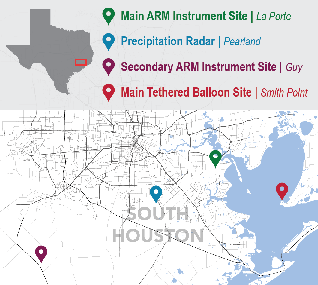
ARM instrument sites will bracket Houston's city center during TRACER's intensive operational period from June 1 through September 30, 2022.
The aim is important to Earth and human ecosystems. Thunderstorms supply needed rain, but sometimes too much. They can wreak havoc on human lives and the built environment. It is better to know when they are coming, how strong they will be, and what feeds their intensity.
Historically, Houston is a hot spot for extreme weather. In 2017, for example, Hurricane Harvey hovered over the region for four days. The storm swept in from the nearby Gulf of Mexico and dumped more than 60 inches of rain, a record for a major U.S. city. Water topped levees and trapped thousands in their homes.
DOE further recognized the importance of studying climate impacts on large cities in March 2022. Officials there announced $84 million in new funding to outfit integrated field laboratories in urban areas. The mission is to collect data crucial to addressing climate-change pressures that cities face.
“Most people impacted by extreme events and climate change live in urban environments,” says Jensen, who sees TRACER as a precursor to DOE’s proposed urban weather laboratories. “We are learning important lessons about collecting measurements in the urban environment.”
ARM instrument sites will bracket Houston’s city center during TRACER’s intensive operational period from June 1 through September 30, 2022.
ARM AT WORK
 enlarge
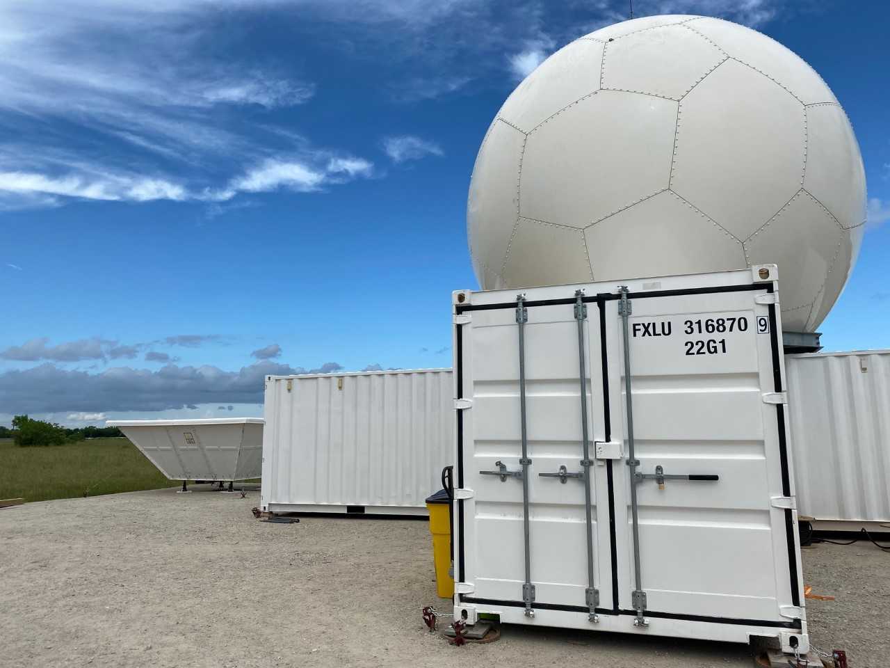
In the foreground at ARM's TRACER instrument site in Pearland, Texas, is a C-Band Scanning ARM Precipitation Radar, which tracks storm cells. To the left, in the back, is a radar wind profiler. Photo is by Jillian Sandoval, Los Alamos National Laboratory.
Two ARM TRACER instrument sites have operated since the campaign began.
The main ARM site, in La Porte, Texas, is just southeast of Houston’s city center. Atmospheric conditions roughly mirror Houston’s eclectic mix of aerosols.
The instruments in La Porte are part of an ARM Mobile Facility, which also includes portable shelters and communications and data systems.
Southwest of the mobile facility, in Pearland, Texas, is a C-Band Scanning ARM Precipitation Radar.
During the IOP, the radar will get a boost from a new software program that automates tracking single convective cells as they evolve to form mature storm systems.
RURAL AND COASTAL MEASURES
Two other ARM sites will operate for the first time during the TRACER IOP.
For two weeks a month, rural Guy, Texas, will host instruments from guest scientists, ARM sensors, radiosonde (weather balloon) launches, and tethered balloon systems (TBS). The objective is to measure the background rural environment, including relatively clean aerosols from soil and sea sources.
In Guy, a four-month campaign on vertically resolved new-particle formation will unfold, with Brookhaven Lab scientist and TRACER science team member Chongai Kuang at the helm.
New nanoscale particles can grow large enough to become cloud condensation nuclei, which influence cloud formation and rain. Kuang’s TBS platforms will collect rare aerial measurements of such particles. The data will provide insights into boundary-layer development and the influence of sea breezes on cloud formation.
The boundary layer is the lowest part of the troposphere, which is directly and quickly influenced by surface conditions.
In Smith Point, Texas, on the eastern shore of Galveston Bay, additional TBS operations will take place for one week each month, overlapping with the TBS measurements at Guy. These measurements will provide important details on the characteristics of the low-level circulations associated with Galveston Bay, including local aerosol conditions.
UNIVERSITIES STEP IN WITH ASR SUPPORT
 enlarge
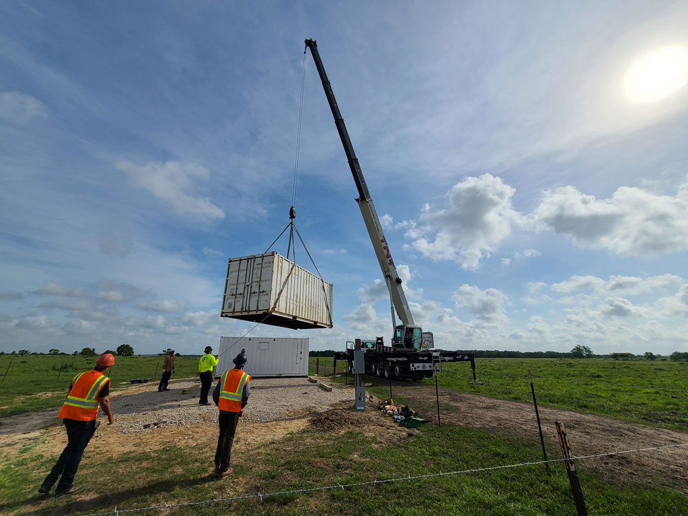
On May 11, 2022, technicians lower a container in Guy, Texas, in preparation for the TRACER intensive operational period. This rural site will host instruments from guest scientists, ARM sensors, radiosonde (weather balloon) launches, and tethered balloon systems. Photo is by Spychala.
Many university scientists, postdoctoral researchers, graduate students, and technicians are headed to the TRACER IOP too.
TRACER participants include 11 teams of university researchers funded by DOE’s Atmospheric System Research (ASR). (Read the project descriptions on the ASR website.)
Ten received grants in 2020. The 11th, led by Alexander Laskin from Purdue University, received funding in 2021.
Laskin’s ASR project will investigate physical and chemical properties of atmospheric particles collected during TRACER, with an emphasis on how they influence the water cycle.
During July, ASR-funded scientist Chris Cappa of the University of California, Davis, will direct TRACER-Carbonaceous Aerosols Thrust (TRACER-CAT). Carbonaceous aerosols predominate in polluted urban environments. These suspended particles include organic carbon and black carbon.
Cappa’s team will investigate how the optical, chemical, and physical properties of black-carbon aerosols affect cloud formation.
Closely allied to Cappa’s work is another TRACER-CAT campaign led by Allison C. Aiken and Manvendra Dubey of Los Alamos National Laboratory (LANL) in New Mexico. With ASR funding, TRACER-CAT-LANL will study how carbon-based aerosols take up water and their effects on light absorption.
ASR-funded scientist Gijs de Boer at the University of Colorado, Boulder, has a campaign that will add a unique observation platform during the TRACER IOP: uncrewed aerial systems. These small, low-flying aircraft can assess pre-convection conditions as well as observe atmospheric circulations on a regional scale.
For the entire IOP, Markus Petters of North Carolina State University will lead the TRACER-Particle Flux Measurements (TRACER-PFM) campaign. Supported by ASR, Petters’ team will use aerosol instrumentation to collect data on new atmospheric particles, including how they grow, age, and dissipate.
MOBILE LABORATORIES
 enlarge
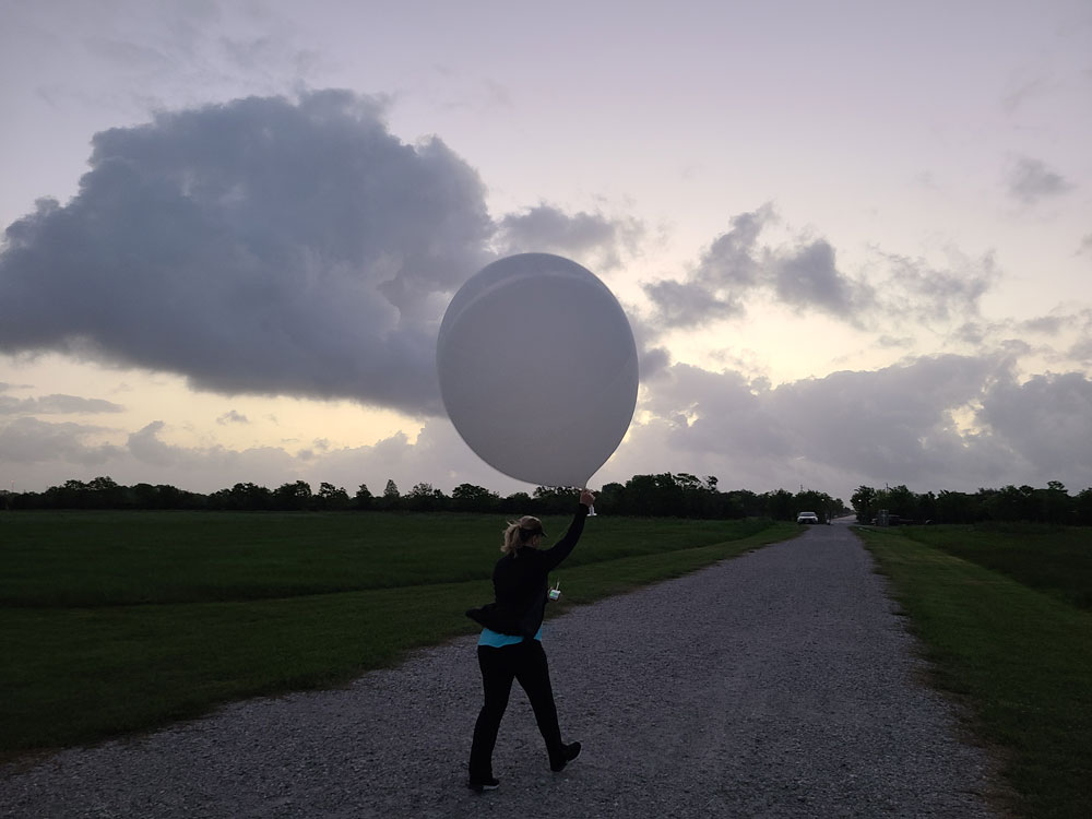
ARM releases a weather balloon from its La Porte site every six hours. On the morning of April 23, 2022, Michelle Kiani launches a balloon at the site. Photo is by Spychala.
Alongside the ARM radar in Pearland, a mobile laboratory from the University of Wisconsin, Madison, will operate as part of the TRACER-Coastal Urban Boundary-layer Interactions with Convection (TRACER-CUBIC) campaign.
Led by the University of Oklahoma’s Petra Klein, TRACER-CUBIC includes two additional mobile platforms stacked with Doppler wind lidars, thermodynamic profilers, and surface meteorological stations.
In her ASR-funded work, Klein hopes to enhance present data on how turbulence and aerosols in the boundary layer influence storms.
Through July and August, Rebecca Sheesley of Baylor University in Waco, Texas, will lead the TRACER-Mapping Aerosol Across Houston (TRACER-MAP) campaign. Data from instrumented sites across Houston will measure the effect of urban pollution on thunderstorms. These data will also quantify how the city’s aerosol regimes change from place to place.
As part of the ASR TRACER-MAP project, Sheesley’s team will use a mobile air quality lab developed by researchers at Baylor and Rice universities and the University of Houston.
TRACER-MAP data sets will inform future DOE projects and improve models of how aerosols affect deep convection in urban systems.
During 30 days of the IOP, Anita Rapp of Texas A&M University will direct a campaign with ASR support to investigate aerosols and deep convection.
Twice daily, a trailer equipped with radiosondes, micropulse lidar, and aerosol-measuring gear will target convection triggered by sea-breeze fronts and maritime air masses.
AEROSOL EVOLUTION AND ULTRAFINE PARTICLES
 enlarge
Convection builds around ARM's La Porte site on the morning of April 11, 2022. Photo is by Spychala.
Jian Wang studies the evolution of aerosols and their impacts on climate and air quality at Washington University in St. Louis, Missouri. In July and August, Wang’s ASR-funded IOP campaign will investigate the microphysics of aerosols, their effect on clouds, and how efficiently they take up water.
Starting July 1, Jim Smith of the University of California, Irvine, will unspool an ASR study of ultrafine aerosol particles.
These seed-like particles suspended in air can be as small as 4 nanometers wide. In the presence of pollutants, the properties of these water-condensation platforms can change, affecting cloud droplet formation.
Back at the Irvine lab, Smith’s group uses unique instruments to study particles captured in the field. One is the thermal desorption chemical ionization mass spectrometer, which identifies a particle’s chemical composition.
TRACER MODELING AND FORECASTING
Convective storm researcher and NASA consultant Susan van den Heever of Colorado State University helped pioneer the idea of a campaign such as TRACER, which investigates aerosol-convection interactions.
“A lot of our fundamental understanding of these interactions comes from her work,” says Jensen.
Backed by ASR, van den Heever will develop enhanced observational and modeling strategies to look at the microphysics of thunderstorms. She and her team will analyze TRACER lightning data and measurements from polarimetric radar.
Polarimetric data provide the orientation and shape of a radar signal.
Marcus van Lier-Walqui, an expert in Bayesian statistical methodologies at Columbia University, is moving in similar directions. His ASR project will analyze polarimetric radar and lightning data to create high-resolution simulations that support TRACER science goals.
His work will leverage rapid-scan data from polarimetric radars to examine storm dynamics in very fine detail.
In an unusual circumstance for modelers, van Lier-Walqui and others will use daily forecast simulations during the IOP to troubleshoot models in near-real time.
OTHER AGENCIES AT WORK
 enlarge
Brookhaven National Laboratory will deploy a Doppler lidar mobile unit in Houston during TRACER's intensive operational period. The unit is seen here in New York City in June 2021 with atmospheric scientist Katia Lamer. Photo is courtesy of Brookhaven National Laboratory.
“TRACER is a huge collaborative effort—and not just across DOE offices,” says Jensen.
During the IOP, NASA will begin the second phase of its TRACER-AQ (Air Quality) experiment. The first phase took place in fall 2021.
In addition, NSF plans some field campaigns that are coordinated with the TRACER IOP.
One is a large effort called the Experiment of Sea Breeze Convection, Aerosols, Precipitation and Environment (ESCAPE). Its airborne and ground-based components will operate from May 30 to June 30.
ESCAPE’s lead scientist is remote sensing expert Pavlos Kollias, who has a joint appointment at Brookhaven Lab and Stony Brook University in New York. He is also the chief scientist of the lab’s Center for Multiscale Applied Sensing (CMAS).
ESCAPE will enlist the use of mobile observatories on wheels, with X-band radars from the University of Oklahoma and Stony Brook.
CMAS will deploy a Doppler lidar truck that was first used in summer 2021 in Manhattan to study airflow around skyscrapers. In Houston, this mobile observatory will, among other things, study variances in temperature and rainfall between Houston’s city center and its suburbs.
In addition, Colorado State University will provide a C-band radar for ESCAPE.
Another NSF-funded project is the Convective cloud Urban Boundary-layer Experiment (CUBE). Researchers are interested in the influence of the urban environment on convection and precipitation. They will deploy flux towers; a scintillometer, which measures fluctuations in turbulence; a Raman lidar; and an extended meteorology network.
CUBE is led by Prathap Ramamurthy and Jorge Gonzalez from the City College of New York.
Gonzalez led a 2021 paper on the grand challenges of urban climate resiliency, with Ramamurthy as a co-author.
DATA AT HAND, DATA TO COME
Even before the IOP, TRACER has generated a large amount of useful, freely available ARM data. There are unique data on the chemical composition of Houston aerosols, for instance.
ARM data are typically available in the ARM Data Center a day or so after they are collected.
Value-added products will follow shortly as they are processed. These are higher-order data products that have gone through extra layers of ARM processing and analysis to make certain data easier to use.
Principal investigators participating in TRACER are required to make measurements available within six months of the campaign’s end.
Other agencies and non-ARM TRACER principal investigators, says Jensen, “have their own data delivery policies and time scales.”
Through TRACER, “we are getting a diversity of observations,” he says. “They will inform our understanding of how detailed atmospheric characteristics affect the weather—and ultimately Earth’s climate and people’s lives.”
ARM is a DOE Office of Science user facility operated by nine DOE national laboratories.
Brookhaven National Laboratory is supported by the Office of Science of the U.S. Department of Energy. The Office of Science is the single largest supporter of basic research in the physical sciences in the United States and is working to address some of the most pressing challenges of our time. For more information, visit science.energy.gov.
Follow @BrookhavenLab on Twitter or find us on Facebook.
2022-19565 | INT/EXT | Newsroom