Applied
High resolution simulations in an urban environment
Increasing our predicting capabilities in urban and coastal areas requires comprehensive ultra- high-resolution datasets from distributed networks of sensors to address the heterogenous nature of the landscape and land-use. CMAS scientists are working on developing these ultra-high-resolution datasets using existing databases and research-quality measurements collected by mobile and fixed urban observatories. One of the most important datasets is the development of a very high-resolution elevation dataset to properly account for building structures in urban centers.
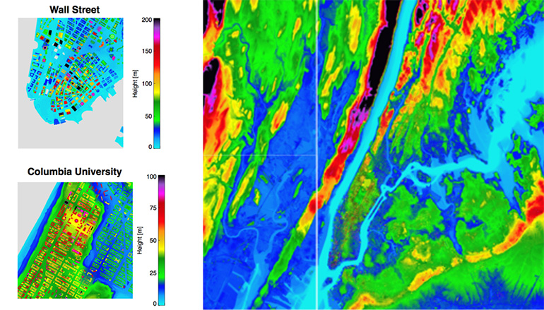
High resolution elevation data (1-meter) of the greater New York city area
Using these databases, CMAS scientists perform ultra-high-resolution simulations to study transport and diffusion processes in street canyons and the occurrence of different flow patterns (e.g., channelling) as a function of ambient wind conditions. Our research focuses on the evaluation of surface boundary conditions and boundary layer parameterization in larger scale models such as the DOE Energy Exascale Earth System Model (E3SM https://e3sm.org/). Using a combination of high-resolution observations and modeling we aim to explore the downscaling from large scale model simulations down to the metropolitan area and further to street and urban canyon scales to study:
- Resolved boundary layer fluxes and turbulence statistics
- Street-level flash-flood, storm surge, and high-wind effects
- Tracers’ transport in street-canyon resolved simulations
- Diurnal cycle of urban heat-island
An example of such simulations conducted by the System for Atmospheric Modeling (SAM, Khairoutdinov and Randall, 2003) is shown here. The domain size is 5000m x 5000m x 2000m, the horizontal resolution is 5 m and the time step is 0.2 sec. The simulation included all the buildings in mid and lower Manhattan modeled as cuboids with the rooftops taken from 1-m resolution rooftop data. The initial conditions were set-up from idealized stable nocturnal boundary layer conditions. The simulation was completed in 2 wall-clock hours using 1,024 processors of a supercomputer. The video here shows only a small portion of the actual domain showing transport of a passive tracer emitted at constant rate at 2 m height near the Hudson river.
High resolution animation
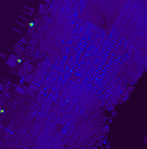
Transport of tracer over Manhattan. The duration of the simulation is 23 minutes and the horizontal wind is 5 ms-1 from the west.
The simulations were performed by Prof. Marat Khairoutdinov of the School of Marine and Atmospheric Sciences at Stony Brook University using CMAS support.
Reference
Khairoutdinov, M.F. and D.A. Randall, 2003: Cloud Resolving Modeling of the ARM Summer 1997 IOP: Model Formulation, Results, Uncertainties, and Sensitivities. J. Atmos. Sci., 60, 607–625