Atmospheric Observatory Opens for Operation in Bankhead National Forest
Scientists will use data from the new Alabama observatory to better understand how forests affect weather and climate
October 1, 2024
By Marguerite Huber, Argonne National Laboratory
 enlarge
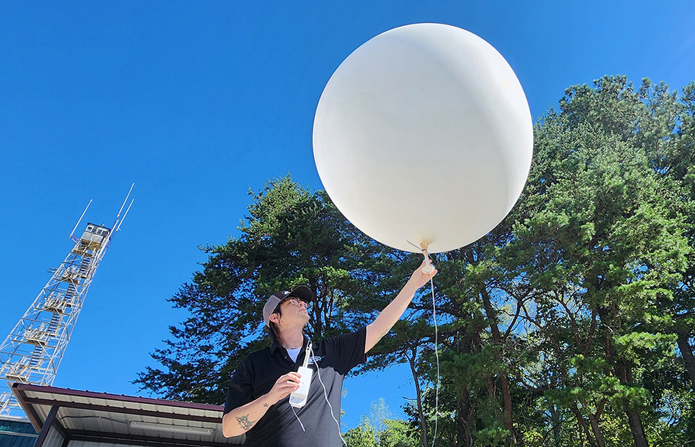
On September 18, 2024, technician Kris Bennefield prepares to launch a weather balloon with a radiosonde attached at the main site of ARM's Bankhead National Forest (BNF) atmospheric observatory near Moulton, Alabama. Bennefield and other BNF staff are working toward the official start of data collection on October 1. Photo is by Mark Spychala, Argonne National Laboratory.
Editor’s note: The following news release is being issued jointly by the U.S. Department of Energy’s Argonne National Laboratory and Brookhaven National Laboratory.
MOULTON, AL — With help from scientists at U.S. Department of Energy (DOE) national laboratories, DOE’s Atmospheric Radiation Measurement (ARM) user facility has established a cutting-edge atmospheric observatory in Alabama's William Bankhead National Forest. The Bankhead National Forest (BNF) observatory officially opens for operation on Oct. 1, 2024.
For at least five years the observatory will provide data for scientists to investigate the complex interactions among clouds, vegetation, and aerosols suspended in the atmosphere. By exploring critical feedback between these areas, the observatory will contribute valuable insights into aerosol-cloud interactions. The data collected will also advance weather and climate models for a more comprehensive understanding of Earth's atmospheric dynamics.
 enlarge
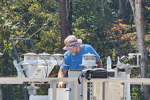
James Martin, an ARM calibration technician who is typically based at the Southern Great Plains (SGP) atmospheric observatory in Oklahoma, works to align the sky radiation collection of radiometers (left) at the BNF's main site in late August. Martin and others also helped prepare BNF instruments and containers at the SGP before their deployment to Alabama. Photo is by Spychala.
Overall, the knowledge gained from the BNF observatory will help scientists make more accurate predictions about the impacts of climate change on local weather patterns in the Southeastern United States and gain a better understanding of how forests influence both weather and climate.
“Our goal in selecting this site and the configuration of instruments is to enable studies from the canopy to the clouds,” said Chongai Kuang, an atmospheric scientist from DOE’s Brookhaven National Laboratory who led the development of the science plan for the BNF. “By introducing state-of-the-art tower facilities, campaign-driven aerial assets, targeted intensive operational periods, and surface-distributed sites within the forested environment and over the larger domain around BNF, we’ll be breaking new ground for interactive land-atmosphere studies.”
ARM is a multi-laboratory user facility sponsored by DOE’s Office of Science. It provides continuous field measurements of atmospheric data from around the world, serving as a key contributor to national and international climate research efforts.
Data are collected from three stationary atmospheric observatories in Oklahoma, Alaska, and the Azores; these observatories sample from a broad range of global climate conditions. ARM also has mobile and aerial facilities.
In the video above, learn more about the new BNF sites and what they will measure.
Bankhead is a long-term mobile observatory that was relocated from Oliktok Point, Alaska, where it operated from 2013 until 2021. Argonne manages the observatories in Alabama and Oklahoma.
Teams from DOE’s Brookhaven and Argonne national laboratories collaborated with other DOE labs and federal, state, and local agencies and organizations—right down to individual Alabama landowners. With support from ARM and DOE’s Atmospheric System Research (ASR) program, Kuang’s team developed the BNF science plan, collaborating with many others to identify the study sites and work out the logistics of getting the equipment in place. Argonne led logistics of site preparation, construction and equipment delivery and placement. Argonne also manages the day-to-day operations, instrument maintenance, and hosts visitors at the research sites through a contract with IntegriWard, LLC.
“The complexities of the atmospheric system cannot be understood through isolated research efforts. Collaboration is critical, and we’re grateful to our partners for their support in establishing this state-of-the-art research facility," said Argonne’s Nicki Hickmon, ARM associate director for operations.
 enlarge
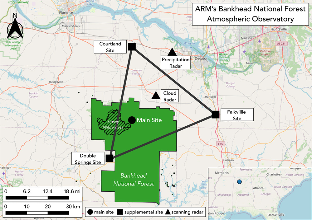
This map shows the locations of the BNF's main site, supplemental sites, and scanning radars. The main site and supplemental sites will be operational as of October 1, while the scanning radar sites are currently under construction. Map is courtesy of Shawn Serbin, NASA Goddard Space Flight Center.
The main observatory site includes a building with equipment for managing communications and data. An adjacent clearing the size of a football field is filled with instruments for monitoring clouds, precipitation, solar energy (sunlight and heat), and other atmospheric conditions. And just over half a mile (1 kilometer) away, a 140-foot (43-meter) walk-up tower outfitted with instruments for measuring detailed characteristics of the forest plants and soil is scheduled for installation in November.
The additional instruments on the tower measure trace gases, pollen, and other aerosols released by plants throughout the vertical profile of the forest. Smaller towers installed closer to the forest floor measure many of these same variables at ground level, along with temperature, humidity, and soil properties.
Supplemental sites positioned at three locations about 30 miles (50 kilometers) from one another form a triangle around the main data collection area. Two additional sites beginning construction now will host radars: a Ka/X-band scanning cloud radar and a C-band scanning precipitation radar.
 enlarge
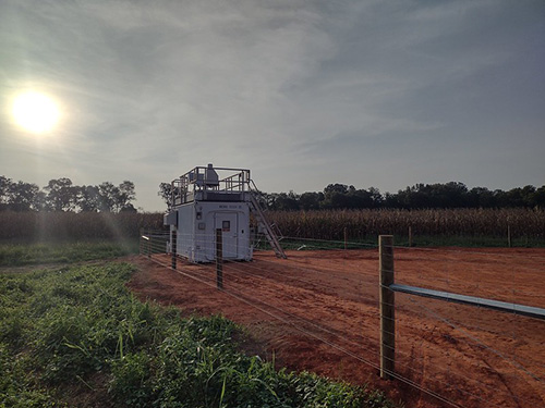
This site at Courtland, Alabama, is one of three supplemental sites that will provide regional context for the measurements coming from the main site. Photo is by David Swank, ARM. To see more from Courtland and the other sites, check out ARM's BNF photo album on Flickr.
"It's exciting to see the observatory come to life, and we look forward to the insights our data will provide into aerosol-cloud interactions and local weather patterns in the Southeastern U.S. region," said Mike Ritsche, site manager for ARM’s Bankhead and Southern Great Plains observatories.
As part of the ARM user facility, the BNF is open for use by the broader research community. Through approved ARM field campaign proposals, collaborating scientists from agencies and universities will bring their own instruments to contribute to the data collection effort and conduct their own research. All the data will be available to the international research community in near-real time at no cost through the ARM Data Center.
For scientists eager to start fieldwork, ARM expects to be able to accommodate guest instrumentation in November 2024 at the earliest.
Researchers are already lining up to use the observatory, and ASR has funded an initial set of research projects. Kuang will lead a team using BNF data, including measurements collected on ARM tethered balloon system flights, to understand how land-atmosphere interactions control particles in the air. Also, DOE’s Early Career Research Program will support a trio of university and national lab scientists planning to work on five-year projects using BNF data.
Argonne National Laboratory and Brookhaven National Laboratory are supported by the Office of Science of the U.S. Department of Energy. The Office of Science is the single largest supporter of basic research in the physical sciences in the United States and is working to address some of the most pressing challenges of our time. For more information, visit science.energy.gov.
Follow @BrookhavenLab on social media. Find us on Instagram, LinkedIn, X, and Facebook.
2024-21671 | INT/EXT | Newsroom


