DOE to Deploy Advanced Observatory to Alabama
Major study will seek to unravel complexity of how forestland-atmosphere interactions impact weather and climate in Southeastern U.S.
November 17, 2023
 enlarge
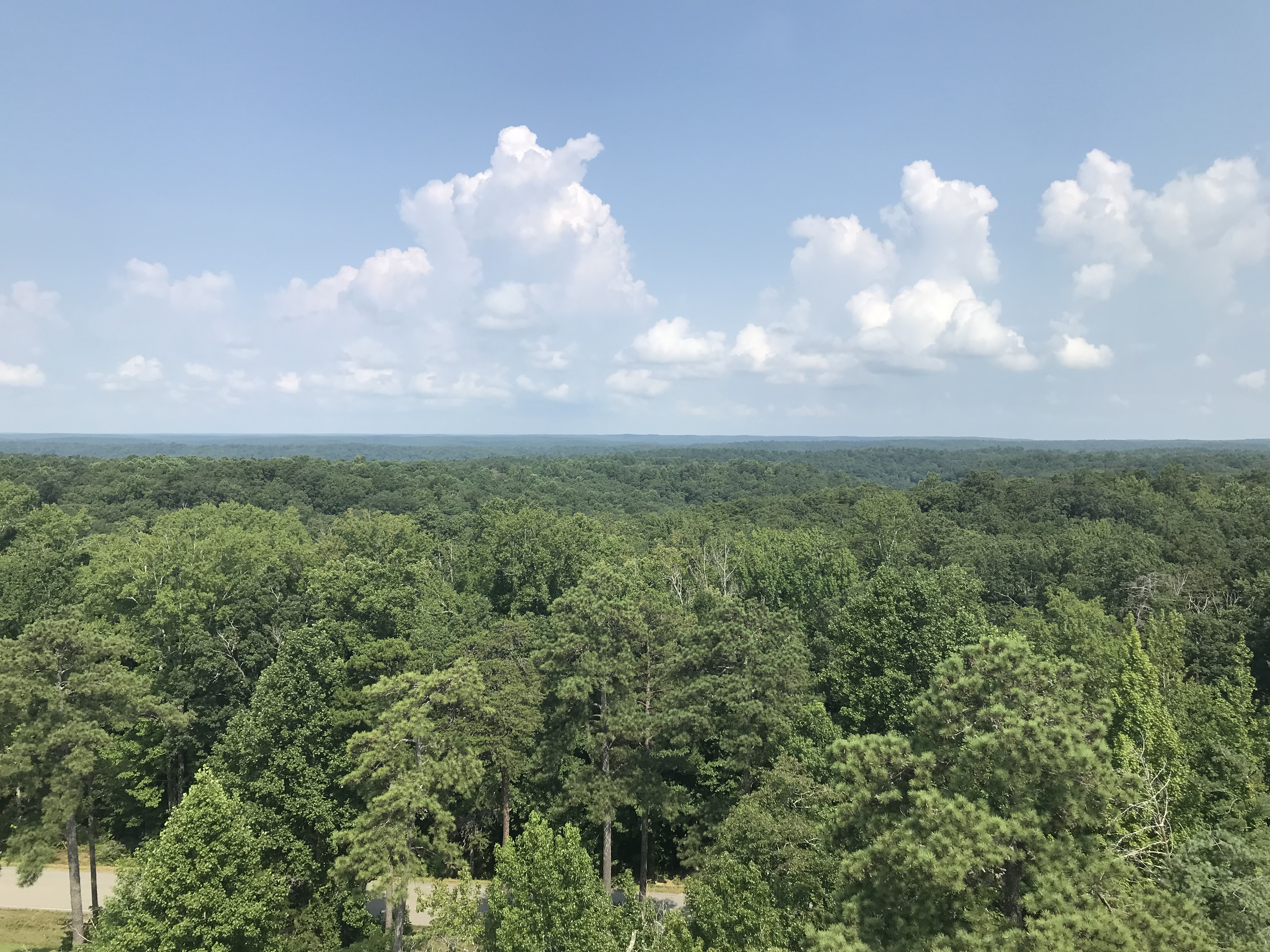
A view of Alabama's Bankhead National Forest taken in July 2021 during a site scouting visit for the upcoming Southeastern U.S. deployment of the third ARM Mobile Facility. The new deployment will study aerosol, cloud, and land-atmosphere interactions. (Image courtesy of the U.S. Department of Energy Atmospheric Radiation Measurement (ARM) user facility. Shawn Serbin/Brookhaven National Laboratory)
On the heels of a storm-saturated spring and summer of record-breaking heat in the Southeastern U.S., a team of environmental scientists from U.S. Department of Energy (DOE) national laboratories will soon set up a suite of sophisticated scientific instruments in Alabama’s William Bankhead National Forest. The deployment of atmospheric and terrestrial-sampling instruments is part of a major five-year research effort supported by DOE’s Atmospheric Radiation Measurement (ARM) user facility and Atmospheric System Research (ASR) program. Their goal: Gather data on how clouds, vegetation, and aerosol particles suspended in the atmosphere interact to affect local weather and Earth’s climate.
They’re particularly interested in the interaction of the terrestrial ecosystem—all those trees and other forest species—with the atmosphere.
“Typically, ARM studies have been looking up—at interactions within the atmosphere—and we’ve learned a lot,” said Chongai Kuang, a researcher from DOE’s Brookhaven National Laboratory who is leading the “site science team” for the deployment of ARM equipment to the main research site. “This deployment, in this region, gives us an opportunity to start unlocking the complex interplay between vegetation and the atmosphere. Our overarching goal is to improve our understanding of how aerosol particles, water vapor, and gases emitted at Earth’s surface—by plants and human activities—interact in the atmosphere to impact the formation of clouds and storms, and learn how the atmospheric conditions affect the terrestrial ecosystem. We want to learn as much as we can about these two-way land-atmosphere interactions.”
The data the scientists collect will help to improve how these factors and interactions are represented in weather and climate models. That, in turn, will inform our understanding of how climate change will impact this region.
 enlarge
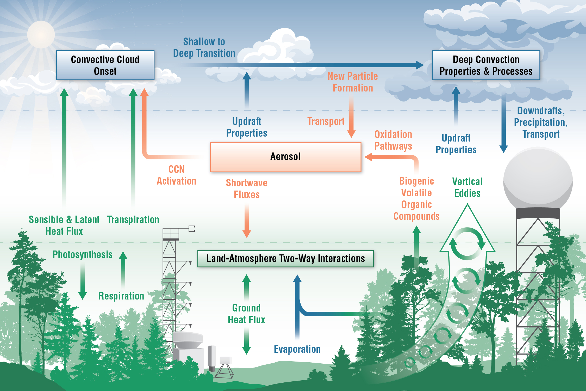
This schematic shows three main topical areas scientists plan to study with instruments deployed in and around the Bankhead National Forest: aerosols, convective clouds, and land-atmosphere interactions. They are particularly interested in gathering data to better characterize how these systems interact. (Tiffany Bowman/Brookhaven National Laboratory)
Measuring the “signal” of the forest
To measure these two-way impacts, the scientists needed a forested location where storms form locally, far from the influence of the coasts. The William Bankhead National Forest in Northwestern Alabama offers the right mix of conditions—lots of towering clouds and severe weather, high humidity, and hundreds of acres of trees and other plants.
“One reason to put this observatory in an area surrounded by a large forest is we can be pretty confident that we are measuring the forest signal,” said Shawn Serbin, who served as a co-lead of the deployment’s site science team prior to leaving Brookhaven this fall for a new role in earth science research at the National Aeronautics and Space Administration’s (NASA) Goddard Space Flight Center.
Forests are important to the Southeastern U.S., producing lumber, paper, and other products adding billions of dollars to the economy. They also benefit the environment by taking in carbon dioxide (CO2) during photosynthesis, partially offsetting emissions of this greenhouse gas. And by deflecting wind and absorbing some of the energy of fast-moving air masses, they can mitigate the impacts of severe storms.
 enlarge
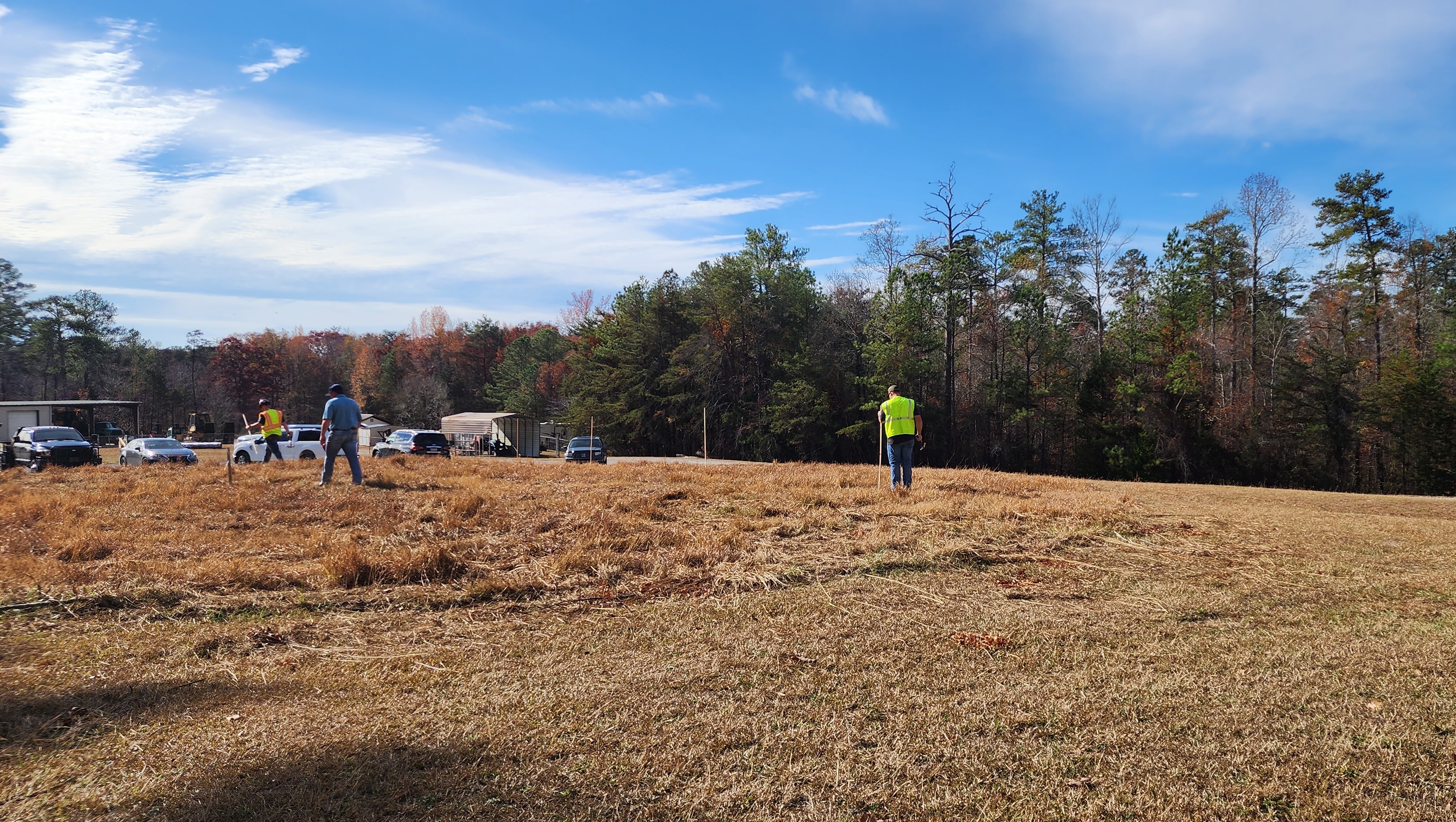
In November 2023, the site operations team from Argonne National Laboratory began work to clear the main instrument field, put up snow fencing around the main office site, and dig trenches for running power and fiberoptic cables to the tower site. (Image courtesy of the U.S. Department of Energy Atmospheric Radiation Measurement (ARM) user facility. Mark Spychala, Argonne National Laboratory)
“For biodiversity and maintaining the resiliency of ecosystems in a time with more severe storms, forests are important to slow down and modify rainfall,” Serbin said.
They also exert a cooling effect by pumping water from the ground into the atmosphere—like a giant version of the mist sprayers you sometimes find at outdoor markets and amusement parks. This natural air conditioning can be a real benefit to a region where heat waves are a big challenge.
But trees, fungi, and other forms of forest vegetation also emit other things: specks of pollen, spores, and volatile organic compounds that react to form aerosol particles in the atmosphere. Heat waves may trigger plants to emit more of these natural, biogenic aerosols. These natural aerosols—along with human-driven aerosol sources such as auto exhaust, factory pollution, and agriculture—can interact in complex ways to impact air quality and alter the temperature of the atmosphere by absorbing or reflecting solar radiation.
Aerosols also potentially increase the formation of clouds; they serve as the seeds around which water vapor condenses to make cloud droplets grow. More particles plus more water vapor could be a recipe for more severe storms.
“We need to better understand how the critical ecosystem services provided by forests—such as maintaining biodiversity, carbon sequestration, and evaporative cooling—are influenced by local weather,” Serbin said. “We also need more clarity on the role trees and other vegetation play in modulating larger-scale atmospheric conditions. Through this deployment, we’ll collect the data we need to improve our predictive models.”
Mobile atmospheric laboratory—plus
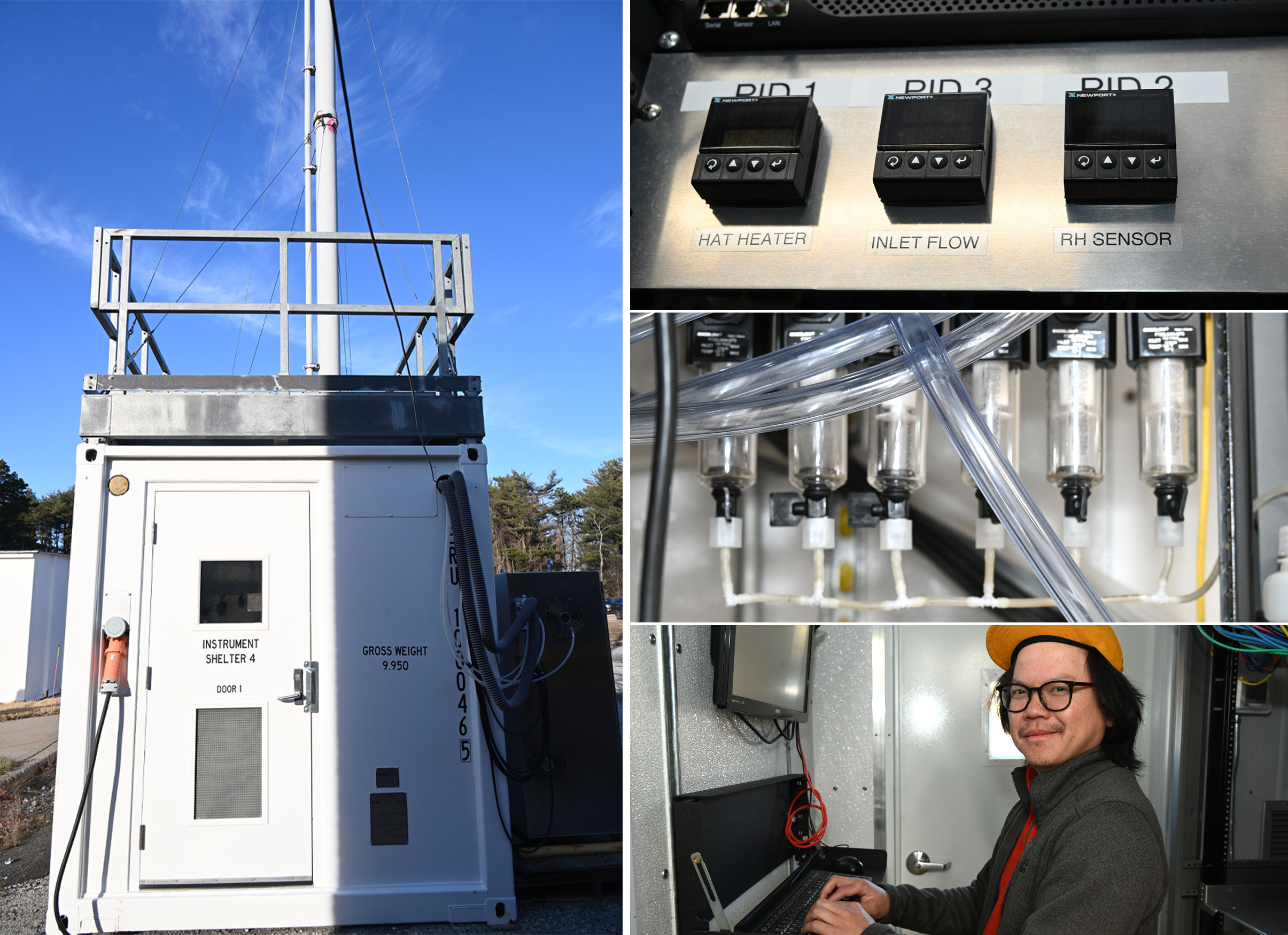
To gather that data, ARM staff, led by a “site operations team” from DOE’s Argonne National Laboratory, will install a suite of instruments known as the third ARM Mobile Facility, or AMF3, deep within the forest. AMF3 includes a shipping-container-type trailer, known as an aerosol observing system (AOS), outfitted with intake tubes for collecting aerosol-laden air samples and rack-mounted instruments for characterizing the particles’ sizes, chemical composition, concentration, and other properties.
 enlarge
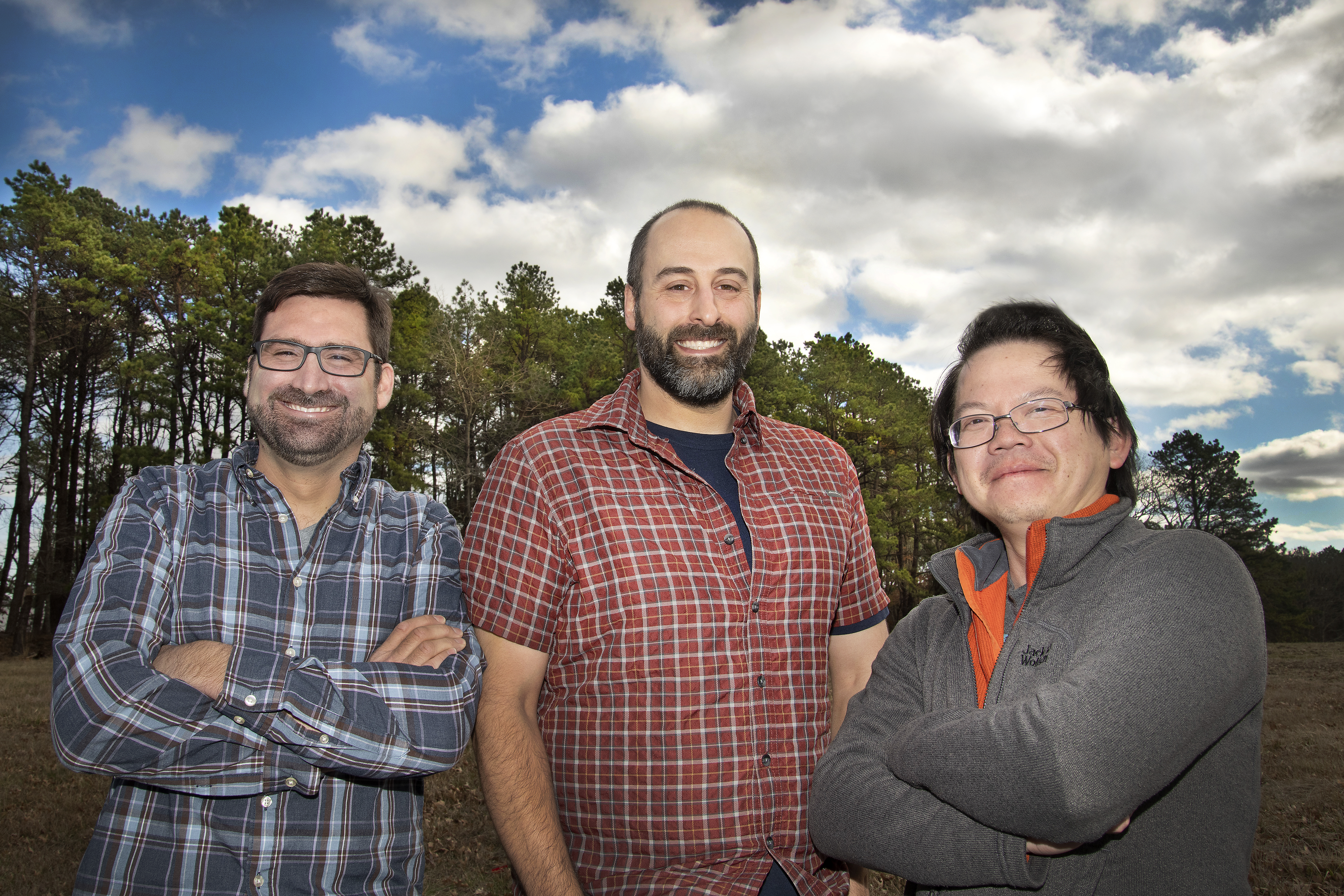
Shawn Serbin, Scott Giangrande, and Chongai Kuang of Brookhaven Lab led the site science team for the AMF3 deployment to Bankhead National Forest throughout the planning and siting stages. Serbin has since taken a postion with NASA, and remains engaged as a research partner. (Roger Stoutenburgh/Brookhaven National Laboratory)
The main observatory site will also include an office building with equipment for managing communications and data. An adjacent clearing the length of a football field in each direction will be filled with instruments for monitoring clouds, precipitation, solar energy (sunlight and heat), and other atmospheric conditions. There will also be a guest instrument facility to support the experiments of visiting investigators and students. And just over half a mile (1 kilometer) away, nestled in the trees with minimal impact on the tree canopy, ARM will erect a 140-foot (43-meter) walk-up tower outfitted with instruments for measuring detailed characteristics of the forest plants and soil.
“We can measure the plants’ exchanges of CO2, water vapor, and energy with the atmosphere as well as the radiation traveling through the atmosphere and in the canopy—the energy of the sun that drives photosynthesis,” Serbin said. By tracking photosynthesis, the scientists can monitor the amount of CO2 stored and water vapor released by the canopy over the five-year study.
Additional instruments on the tower will measure trace gases, pollen, and other aerosols emitted by plants throughout the vertical profile of the forest.
“We’ll be able to see the aerosols coming off the vegetation right in the forest,” Kuang said.
Smaller towers installed closer to the forest floor will measure many of these same variables at ground level, along with temperature, humidity, and soil properties.
“In northern and greater Alabama, soil moisture availability is an ever-present concern for local farmers, where droughts not only impact agriculture, but also wildfires,” Kuang said.
The site science team also hopes to collaborate with other agencies to send instruments to higher altitudes to map the 3D structure of the forest as well as the spectral properties of leaves. This “spectral remote sensing” technique, partially developed by Serbin during his time at Brookhaven, translates measurements of light and infrared radiation absorbed and reflected by the plants into “fingerprints” that give insight into their chemical makeup.
Many studies have collected similar detailed biochemical data in forests, and many others have collected detailed data on atmospheric aerosols, clouds, and weather. But those land and atmospheric measurements were always separated in space and time. Scientists had to build models to try to understand the connections—how the land surface is influencing local weather and climate, and how local weather and climate conditions are in turn influencing the land surface.
“By deploying a suite of land and atmosphere-sampling tools together, we can do this at the same location and at the same time over a multiyear period,” Kuang said.
The simultaneous measurements will allow the team to directly connect measurements in a forest ecosystem—from the soil surface through the vegetation canopy—with the atmospheric features to learn how these factors are coupled. In addition, the multiyear deployment will capture data relevant to different time scales—both the shorter time scales that drive high-impact weather and the longer-term time scales that drive climate processes.
 enlarge
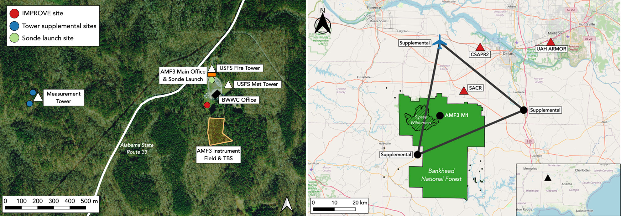
The map on the left shows the planned Phase 1 installation locations for the Bankhead National Forest (BNF) main site, office, and tower near the Black Warrior Work Center (BWWC) and U.S. Forest Service (USFS) towers. AMF3 is the ARM mobile observatory that will be deployed. The map on the right indicates the planned partner facilities and ARM radar (SACR/CSAPR2) and supplemental sites for Phase 2 of the BNF installation. (Shawn Serbin/Brookhaven National Laboratory)
Supplemental sites
After the initial site is set up, ARM, with guidance from Brookhaven scientists, will also place instruments beyond the forest. These supplemental sites will be positioned at three locations about 30 miles (50 kilometers) from one another, forming a triangle around the main data collection area.
“These sites will have meteorological instruments for monitoring temperature, water vapor, air motion, and land-surface properties to help us better characterize what’s coming into the main site domain and going out of the main site domain. They provide regional context for the highly detailed measurements being made at the main site,” Kuang said.
In addition, in a first for ARM, the supplemental sites will be outfitted with mini AOS units developed by the Brookhaven team specifically for this deployment. These are much smaller, lower power, less complex versions of the main-site AOS, but they are still able to make research-grade aerosol measurements. Covering more ground, and the atmosphere above it, will allow the scientists to explore how atmospheric interactions change above different types of land surfaces—from forested to rural and agricultural environments. Partnering with local collaborators on urban aerosol measurements will bring another dimension to the study.
“Having these aerosol sampling tools at the supplemental sites will help us distinguish particles coming into our domain from outside the area from those being formed in the forest—and potentially distinguish the influences of biogenic, forest-generated aerosols from those of particles and gases emitted and transported from nearby urban, industrial, or agricultural areas,” Kuang said.
Two additional locations outside the forest will house scanning radars for tracking atmospheric conditions above the main research area. “Placing the radars outside the forest gives us better spatial coverage of the high-density, vertically pointing measurements at the main site—and gets us away from the challenges of operating a radar under the thick forest canopy,” he added.
 enlarge
Left: The aerosol observing system (AOS) is a shipping container outfitted with a 10-meter-tall intake stack for drawing aerosol-laden air samples into analysis instruments inside. Instruments include (top to bottom): inlet flow sensors, flow rotameters, and system computers. (Kevin Coughlin/Brookhaven National Laboratory)
Collaborators, partners … and more tools
While the Brookhaven team led the development of the science plan for the deployment, they collaborated with many others to identify the study sites and work out the logistics of getting the equipment in place. As noted, site operations staff from Argonne Lab are overseeing the installation of equipment. They will also manage day-to-day operations, maintain equipment, and host visitors at the research sites.
The Brookhaven and Argonne teams also collaborated with other DOE labs and other federal, state, and local agencies and organizations—right down to the level of individual Alabama homeowners.
For example, as the researchers were exploring where to locate the study, they got help from the U.S. Forest Service and the National Ecological Observatory Network program run by the National Science Foundation. The U.S. Department of Agriculture connected them with local community groups. Serbin, Kuang, and others attended community meetings and even went door to door.
“There’s long-standing support for improving our ability to predict severe weather, which is an all-too-common occurrence in the Southeastern U.S. region,” said Scott Giangrande of Brookhaven Lab, another co-leader of the site science team. “The growing population and potential increases in severity of storms in this region will make homeowners more vulnerable to damage and possibly even fatalities. So, when we described what we’re bringing to the table, there was high community interest in this research.”
The researchers noted that two of the three proposed supplemental sites were selected as a direct result of those community conversations. The third, near Courtland Airport, had previously hosted research equipment belonging to the National Oceanic and Atmospheric Administration (NOAA) and the University of Alabama in Huntsville (UAH), making it an attractive location for a DOE deployment, Kuang said. The team also worked with UAH and ARM to help choose potential radar sites. NOAA may also provide atmospheric profilers.
“And we’re hoping to continue to partner with Shawn and other scientists at NASA, and to make use of their atmosphere and land-imaging satellite assets, to further promote the site as a nexus for land-atmosphere boundary layer studies,” Kuang said. “These partnerships really multiply the impact of the observations we make by providing additional context for our measurements and filling the gaps in the things we can’t measure.”
 enlarge
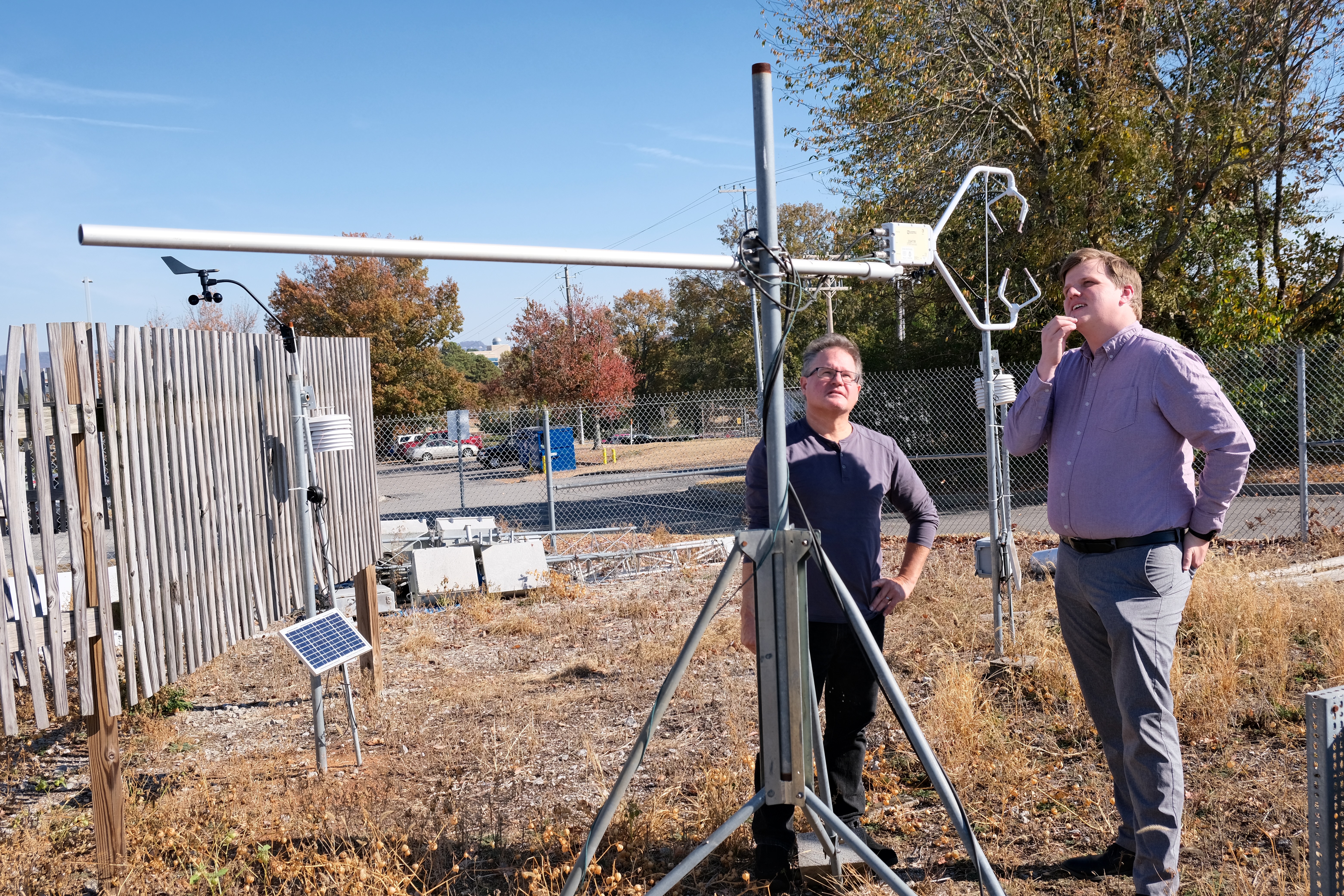
John Mecikalski and Sean Freeman of the University of Alabama in Huntsville (UAH) discuss the operation of a sonic anemometer deployed on UAH's campus. These atmospheric scientists will be among those conducting research as part of the AMF3 deployment. (Liz Junod/UAH)
As part of the ARM user facility, the site will be open for use by the broader research community. There will be room for collaborating scientists from agencies and universities to bring their own instruments to contribute to the data collection effort and conduct their own research. For example, there will be a guest AOS at the main site with its own inlet and supporting sampling infrastructure; an area for offices, preparation, and other tools; as well as room on the tower where smaller, lightweight guest instruments can be mounted. The supplemental sites also will have power and some supporting infrastructure for guest deployments.
John Mecikalski and Sean Freeman, two professors from UAH, are among several recipients of ASR funding for research as part of this deployment. Their studies will use advanced modeling based on the ARM data to explore specific interactions of aerosols with clouds and how clouds form and evolve.
Members of the site science and site operations teams also worked with scientists from Alabama A&M—a historically Black, land-grant university in Huntsville—who gave the site science and operations teams guided tours of several locations in agricultural and urban environments and presented opportunities for collaboration during the AMF3 deployment. Likewise, scientists from the University of Alabama, Tuscaloosa, spoke with the team on several occasions about the critical weather and ecological challenges facing the Southeastern U.S. They even gave presentations at DOE meetings in support of the AMF3 planning and site-selection process.
“These local scientists spent a lot of time with us and are part of the reason we are here,” Kuang said, noting that he hopes for additional research opportunities for students from these universities over the course of the study. “At the very least, we are planning a summer school so that students can get some hands-on experience with how the instruments operate, data quality control, and data analysis.”
Deciphering the data
Making sense of all the data collected during the deployment will be an enormous challenge. “It’s both a challenge and opportunity,” Kuang said—a chance to unravel the complex interactions of the atmosphere and ecosystem in a way that’s never been done before in the region.
 enlarge
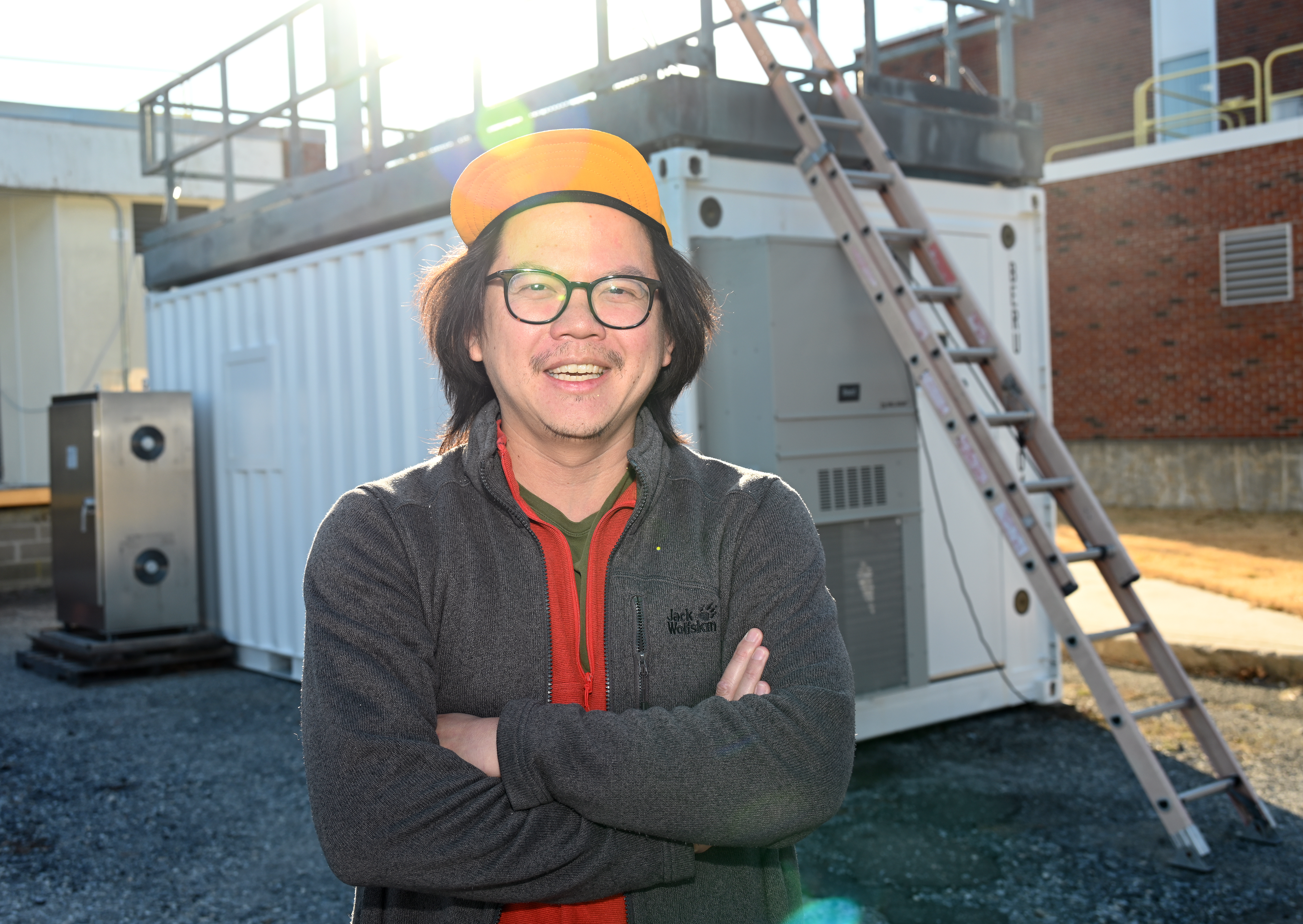
Brookhaven Lab atmospheric scientist Chongai Kuang, who leads the site-science team for the Bankhead National Forest AMF3 deployment, stands outside one of the aerosol observing system (AOS) units being outfitted with equipment for the study. (Kevin Coughlin/Brookhaven National Laboratory)
The good news is that scientists around the world can help. All the data will be available to the international research community in near-real time at no cost through the ARM Data Center. Members of different research communities will be looking at the data to make connections between the many variables, and the modeling community will use the data to improve their models.
The deployment also offers opportunities for using data to drive the science in real time.
“There’s a lot of interest in smart instruments that can talk to each other in real time across vast distances, using artificial intelligence (AI) and machine learning to connect their measurements,” Serbin said.
“For example, imagine I have a little instrument 100 kilometers away measuring something. If it can understand the data right there, instantaneously, and identify a phenomenon that we should be observing at the same time, it could direct some other measurements to happen,” he said.
“You’d have to have very fast number crunching,” Serbin noted. “But because we’ll have a main site with all these instruments collecting data potentially able to communicate with each other, and distributed sites and partner instruments, this could be a perfect testbed for developing the mathematical methods and ‘edge computing’ capabilities needed to drive these AI-supported measurements.”
Serbin’s new role at NASA will provide new opportunities to grow the “ecosystem” of the AMF3 Bankhead National Forest deployment and support the development of emerging measurement technologies that target coupled land-aerosol-cloud interactions, Kuang said.
The ARM and ASR aspects of this deployment are funded by the DOE Office of Science (BER).
Brookhaven National Laboratory is supported by the Office of Science of the U.S. Department of Energy. ARM is a DOE Office of Science user facility operated by nine DOE national laboratories. The Office of Science is the single largest supporter of basic research in the physical sciences in the United States and is working to address some of the most pressing challenges of our time. For more information, visit science.energy.gov.
Follow @BrookhavenLab on social media. Find us on Instagram, LinkedIn, Twitter, and Facebook.
2023-21398 | INT/EXT | Newsroom