
Technology Development & Applications and Meteorological Services
Meteorological Services (Met Services) is responsible for the maintenance, calibration, data collection and data archiving for the weather instrumentation network associated with atmospheric dispersion concerns for BNL. This includes measuring wind speed, wind direction, temperature, rainfall, barometric pressure and relative humidity. Wind speed, wind direction and temperature are measured at 85 meters, 50 meters and at 10 meters. Rainfall, relative humidity and barometric pressure are taken at the 2 meter height. The 85-meter (280-ft.) meteorological tower, placed in operation in May 1981, is located in an open field west of the majority of the Brookhaven building complex at latitude 40052.20'N and longitude 72°53.35'W and its base is 24 m (80 ft.) above sea level.
The 85-meter and 50-meter sensors are mounted on this tower. A foldable-mast, 10-meter tower is located approximately at the center of the Meteorological field. Again, fully redundant sensor sets are present. This site also has the 2-meter barometric pressure and temperature sensors.
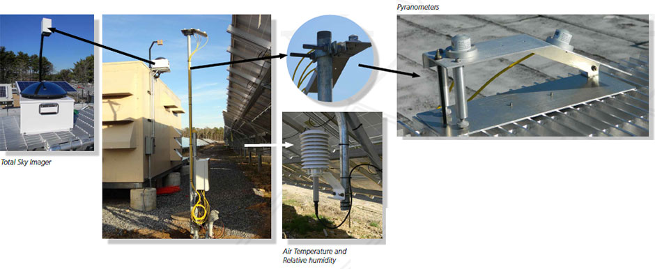
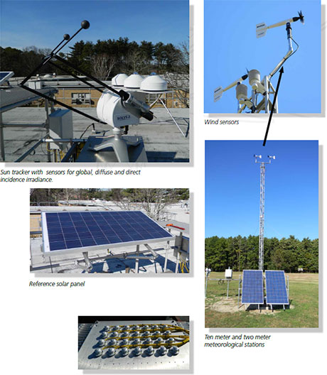
Met Services maintains a platform on the roof of building 490D. This platform houses the base station for solar incidence measurements. Instrumentation at this location includes; a Zipp and Zonen model Solys-2 suntracker with a Kipp and Zonen model CGR-4 pyrgeometer and a Kipp and Zonen model CHP-1 pyrheliometer, Kipp and Zonen model SP-lite2 pyranometers (one at the 27° angle of inclination for the panels at the LISF and one horizontal), a YES model TSI-880 Total Sky Imager, a YES model MFR-7 Rotating Shadowband radiometer and two Kipp and Zonen CMP-22 research grade pyranometers (one shaded and one unshaded). Redundant rain gauges are also located on the roof of this building.
In addition to the regulatory and DOE required meteorological network, Met Services, under separate funding, maintains a network of sensors related to solar power research. This network includes total sky imagers, pyranometers, air-, soil- and panel-temperature sensors, and humidity sensors. There are 25 stations spread throughout the ~200 acre Long Island Solar Farm.
Group Personnel
John Heiser, Principal Engineer - Group Leader
- Andrew McMahon, Associate Staff Engineer
- Scott Smith, Environmental Science Associate
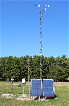
Met Services 10-meter and 2-meter meteorological stations
Meteorological Monitoring at the Long Island Solar Farm
Clouds can have a significant impact on the performance of a solar array used for power generation. To investigate this impact, both in short term (minutes to hours) and longer term (days), BNL has deployed a meteorological sensor network in and around the 32-megawatt Long Island Solar Farm.
The array is instrumented with horizontal and in-plane solar irradiance sensors at 25 locations, along with air and panel temperature sensors. Additionally, relative humidity and soil temperature (both under the array and between arrays) are monitored at 10 locations.
Meteorological Base Station
BNL maintains a base station of high quality meteorological sensors. These include 10-meter and 85-meter towers equipped with sensors to monitor wind speed, wind direction and air temperature. Barometric pressure, relative humidity and air temperature are monitored at 2 meters. The solar base station includes a pyrgeometer, a normal incidence pyrheliometer, global and diffuse pyranometers, a reference set of the same pyranometers used in the large solar array, a reference solar panel of the same type used in the large array and a Total Sky Imager.